Yacuviñay — which means “Eternal Water” in Quechua — is an archaeological site from the Inca era located just outside of Atahualpa, a canton in the province of El Oro in Ecuador. The name emphasizes some of the greatest attributes of the area — its subterranean sources of water such as natural springs — and the site has yet-to-be-discovered opportunities for cultural preservation and tourism dollars.
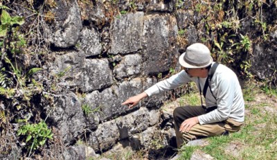
The residential complex stretches about 100 hectares and in its ruins have been found many archaeological pieces and human skeletons. According to historian and professor Manuel Espinosa Apollo from the Central University of Quito, all of the city’s infrastructure is similar to a lost city of the Incas –he speculates that the city was an agricultural citadel, covered with a series of terraces and platforms for the production of vegetables and fruits. There are also perfectly assembled baths, aqueducts and cisterns, with places set aside for the worship of water and the sun.
Marco Espinosa, a native of Atahualpa and local expert on the ruins, believes that Yacuviñay dates back to 1533, possibly to the historical moment in which the Inca brothers Huáscar and Atahualpa, as heirs of the Tahuantinsuyo, disputed its territory. According to historical accounts, Huáscar won the goodwill of some Cañari chieftains so they pledged their troops to him and helped him win a bloody battle over Atahualpa.
The archaeological complex is divided into 5 sets of ruins, which are known as El Mirador, Cruciforme, Residential, Uzhnu and Temple Catequila. The site has been studied recently but not extensively by Ecuadorian cultural authorities; however, it has always been known by the residents of nearby Paccha — the town’s Cultural Rescue Group has found and restored several archaeological pieces.
Tourism potential
The Mayor of Atahualpa, Exar Quezada, believes that rescuing the ruins of Yacuviñay could be a source of income for the canton. “This represents an immense archaeological value and the most important thing that we have in the city,” he said. “Currently, the main sources of income are farming and mining, but this site could have high tourism potential, which would give us another economic source.”
Yacuviñay is also in a good location, according to the mayor, for tourism with its scenic views and access to main roads. Santa Rosa is just a few hours away, and one of the driving routes to and from the site is possibly part of the legendary trail of the Inca.
Atahualpa is a small municipality, with an annual budget of only about $1.5 million, of which 80% is administrative expenses; the town is small — only 6000 residents — and receives government aid. But the mayor is hopeful that the tourism potential has been recognized because, two months ago, the government announced an investment of $60 million to begin reworking the road known as Passage-Paccha.
To get to Yacuviñay, take the road Machala-Santa Rosa-Piñas to Paccha. A shorter route is the Passage-Paccha; however, due to the poor state of the road, many tourists and researchers prefer the longer route.
Originally published in El Telegrafo on September 6, 2015 — translated and edited by GringoTree staff.


