

It can be argued that Cuenca’s beauty comes from three main attributes: the views of the mountains encircling the city, the Spanish and French Colonial architecture of el Centro dating back to the 18th Century or earlier, and the four rivers for which the city was named “Santa Ana de los Cuatro Rios de Cuenca."(For more information on Cuenca’s rivers, see this YapaTree article)
Much to the credit of the city planners, the Cuenca riverfronts are mostly all accessible along their paths down from the mountains west and north of the city, and crossing Cuenca until all four merged on the southeast side into a single river called the Rio Cuenca.
Today I will share some details about the route that should help you navigate by all four of Cuenca’s rivers easily including alternate loops, detours with the best views, the easiest starting point for downhill riders, parks and other sights, places to stop for food and drink and a list of TIPS at the end drawn from my recent rides.
So, let’s mount up!
The Ciclovía Cuenca Unida leads you along all four of Cuenca’s rivers in 2 hours
The “Ciclovía Cuenca Unida” is the crown jewel of Cuenca’s 63 kilometers (39 miles) of bicycle lanes and paths. Some of it runs through the crowded El Centro and surrounding neighborhoods for those who need to get from point A to point B. But, in addition to using these paths for daily commutes, the Ciclovía Cuenca Unida offers a safe and comfortable route on which to see Cuenca from its southwest to northeast sides and to tour the four rivers at your own pace & style.
Most of the riverfront miles are bordered by wooded public parkland, as well as public sidewalks and roads with views of these clear, rocky rivers and their gentle rapids. All four rivers, including long stretches of the Rio Tomebamba and the Rio Yanuncay, can be seen in a single bicycle tour along the “Ciclovia Cuenca Unida” – a 13.5 kilometer (8.4 miles) paved path especially for bicycles.
The route can easily be ridden in two hours, though you may prefer a more leisurely ride and extra time to enjoy the sights and refreshments along the way.
A map of the system (shown below) is found in the free “Manual del Ciclista” booklets available at the Bici Cuenca office on Paseo Tres de Noviembre near Puente Juana de Oro just below El Centro. You may also want to follow your progress with one of several phone mapping apps which track your location and progress and point out interesting, off-route sights. Many find a map unnecessary as the route is well marked.

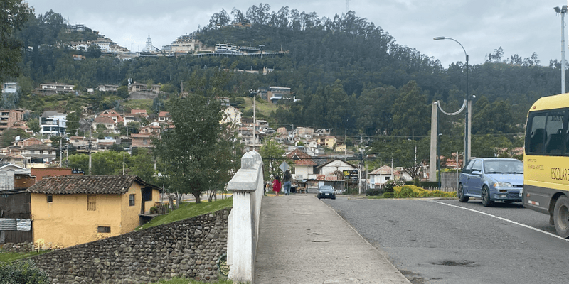
Start at Puente Yanuncay for an easier, more downhill ride
To ride the complete route and take a tour of the rivers, you can start at either end of the route. At one end is the southwest terminus - Puente Yanuncay where the river passes under Av. de las Americas (just across the bridge from the Rio Yanuncay Tranvía stop). At the other end the northeast terminus is located at the Tranvía stop at Parque Industrial.
The west-to-east route starting at Puente Yanuncay is more popular as the grade is mostly downhill for the first two-thirds of the ride - 9.2 km (5.5 miles) from Puente Yanuncay to Parque Eucaliptos. After Parque Eucaliptos, the grade begins to gradually climb uphill, though gently until close to the last few kilometers. As noted, either end is near the Tranvía which is super handy because you can take your bike to the starting point on the Tranvia (Note the map in the “Manual del Ciclista” booklet says the northeast point of the Ciclovía Cuenca Unica is at the Michilchig Tranvía stop. It isn’t – it’s at the Parque Industrial stop).
Easy riding, historical structures, and great food and beverage
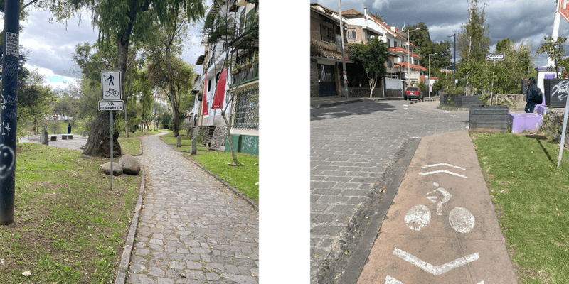
At Puente Yanuncay, the paved Ciclovía begins at the northeast corner of the intersection of Av. de las Americas and Av. Primero de Mayo, along the south bank of the Rio Yanuncay. This is part of the linear park, “Parque Lineal”, that runs along the entire south bank of the Yanuncay and frequently on its north bank as well. While this is a starting point for the paved Ciclovía, be aware that there is at least a mile of a well-maintained cinder path, creating a beautiful ride going west through the Parque Lineal from Av. de la Americas.
Looking across the river from the path, you’ll see the family-friendly “Piedras de Yanuncay” park that was opened in August 2022, as well as cows, chickens, and a few horses in small farms along the river’s north bank.

Near this starting point of the Ciclovia, a sign welcomes riders and displays the full route of the Ciclovia Cuenca Unida. Before starting your ride, you may want to load up on food at the popular restaurant and gift shop La Yunta across the street. They’re open for breakfast through dinnertime every day of the week. As you head east on the Ciclovia, parallel to Avenida Primero de Mayo, you’ll see that the paved Ciclovía with its 6” high concrete barriers will veer away from the river and park and follow Primero de Mayo.
I recommend you leave the Ciclovía briefly and follow the cinder path in the park for a more scenic ride instead. After a few blocks, you’ll reach Av. Loja, where you can steer right and rejoin the Ciclovia as it runs between the Parque Lineal and Av. Primero de Mayo. Along this next stretch of approximately one-quarter mile, you’ll note a historic, but still functioning police station, and across the river, a nearly abandoned fútbol field. It looks little used perhaps because it is reachable only by an old and very steep set of stairs going up to Av. 10 de Agosto across the river.
The next intersection is the Av. Pichincha, notable for the “Reloj Floral” (Flower Clock) on the slope of the hill across the river.
Continuing southeast along Primero de Mayo, you’ll pass through a neighborhood of upscale condominiums on your right, and a beautiful section of the Parque Lineal and the Rio Yanuncay on your right. There are a number of appealing restaurants in this section along Av Primero de Mayo. Though it may be too early in your ride to stop for refreshment, some of our favorite places in this stretch are Goody’s Gelato at the corner of Fernando Aragon; and for dinner, Moca-San - a sushi restaurant located just west of the intersection at Avenida Solano.
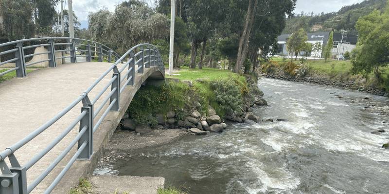
The Avenida Solano intersection is also the site of “Tres Puentes” (Three Bridges). Two of the bridges carry north and south-bound traffic on Avenida Solano. The third bridge, in between the other two, is a historic monument of sorts that is no longer in use. Here, you’ll cross the bridges to follow the Ciclovía to the north bank of the Yanuncay, where the paved, protected Ciclovía continues.
See the Rio Tarqui with a short detour or a loop
It’s in this stretch where you may want to go off the prescribed path to get a look at the Rio Tarqui. At the beginning of this article, we promised you a route that would take you to all four rivers.
If you want to spend some time along the Tarqui, head south on Av. 24 de Mayo at the roundabout (redondel) at Tres Puentes. Then follow the path east along 24 de Mayo for approximately one mile and admire the Rio Tarqui on your left. At the next major intersection, where 24 de Mayo meets Hernán Malo, turn left and cross the bridge over what is now just the Rio Yanuncay. The Tarqui merges into the Yanuncay out of view from this route, just west of this bridge. After crossing the bridge, you will turn to the right and rejoin the Ciclovía to continue riding east.
If you would rather see where Rio Tarqui and the Rio Yanuncay meet instead, stay on the Ciclovía by turning left at the Tres Puentes bridges and follow it until you see a cinder path bearing off to the right that runs close to the Yanuncay. That path will take you to a point where you can see the meeting point of the Yanuncay and the Tarqui.
When you’re ready to move on, the cinder path will take you back to the main paved path.
But If you want to take a third option, you can do a loop, as I did on my most recent ride. That allowed me to bike along the Tarqui and also see its meeting place with the Yanuncay.
I left the Ciclovía and turned right at Calle Francisco Moscoso, crossing the Yanuncay. I rode east on Av. 24 de Mayo back to the Tres Puentes bridge and rejoined the Ciclovía on the north side of the Yanuncay. I’m glad I did because I noticed something I had missed on prior rides, The Botanical Gardens.
Just before the turnoff from the main path to the cinder path that leads to the junction of the rivers, I noticed a footbridge that crosses the Yanuncay. This bridge leads to the Botanical Gardens, which is worth a visit. As a bonus to the beautiful and diverse gardens, there is a small tienda at the entrance with refreshments to rehydrate.

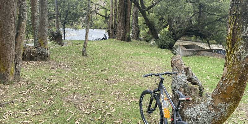
Parallel cinder paths put you closer to the rivers
Continuing eastward, the paved path takes you away from Yanuncay and goes through a residential neighborhood along Avs. 27 de Febrero and 10 de Agosto. Again, you have the option to follow a cinder path that will keep you closer and in view of the river. It’s a more scenic choice, but note that when riding on the cinder paths, you are sharing space with runners and pedestrians.
Parque El Paraiso - great city park, perfect for your mid-ride break
Either the paved path or the cinder path along the Yanuncay takes you to a redondel at Av. 10 de Agosto at the southwest corner of Parque El Paraiso. Parque El Paraiso is a great city park. It offers beautiful scenery, as both the Tomebamba and the Yanuncay run through it and merge there.
The Park offers big open spaces, ponds, kids’ play equipment, wooded areas, and sports courts in addition to facilities for bicyclists. On weekends, you’ll find food and vendor carts along with people playing sports and flying kites. One Sunday visit to this park reminded me of Seurat’s painting “A Sunday Afternoon on the Island of La Grande Jatte” for the number of diverse types of people I saw enjoying this park.
Two of the bicyclist-friendly amenities I noticed were the “BiciBar" - a ride-up refreshment stand next to the bike rack area - and two restrooms large enough to protect your bike by bringing it inside. Neither the restrooms nor the BiciBar were open when I passed around 11 am on a Sunday.


Following the main Ciclovía route again, you will wind around some medical facilities and then cross a small bridge over the Tomebamba. The route then parallels Av. Pumapungo. After a half-mile or so, you can see the meeting place of the Tomebamba and the Yanuncay. If you want to spend more time in Parque El Paraiso, there are cinder paths throughout the park that will take you right up to the point of the meeting of the two rivers.

A glimpse of Cuenca’s “forgotten” river – Rio Michilchig
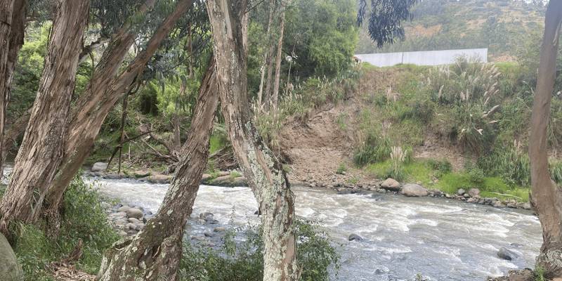
After Parque El Paraiso, the main path follows Av. Pumapungo, with residences and small businesses on your left and the Rio Tomebamba on your right. There are no major landmarks in this stretch, but it is a tranquil and relaxing section. When you reach Parque Los Eucaliptos, you’ll see another river junction – that of the Rio Michilchig, as it runs into the Tomebamba.
The Michilchig seems to be the forgotten river of Cuenca – perhaps because it is narrower and shorter than the others. It is also hard to pronounce! What I saw of it looks more like a stream than a river but it is deemed a river and does merge with the Tomebamba. The Ciclovía map shows a cinder path that runs along the Michilchig from Avenida España, near the Airport, south to Av. Gonzalez Suarez. On the day I looked for this path, it appeared that access to its north end was closed.
The Rio Machangara meets the Tomebamba near Parque Los Eucaliptos
It's around the meeting point of the Michilchig and the Tomebamba that you notice the elevation starts to go uphill. The main path goes under Av. Las Americas and follows Av. Cumanda on your left and the Tomebamba on your right. You’ll see the Engineering College (CICA) and the tennis and football courts right next to the Cross Tenis school. In a quarter mile or so, the path along Av. Cumanda goes to the left, away from the river.
At that turn, you may want to follow the cinder path for the view close to the river. It leads you to the point where the Rio Machangara meets the Tomebamba and creates the Rio Cuenca. The Rio Cuenca flows east of Cuenca and merges with other rivers that will ultimately flow into the Amazon.
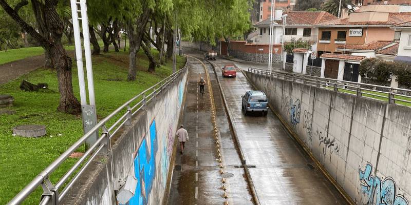
A steep climb begins as you follow the Machangara, which flows down from the north
Back on the main route, after the sharp turn to the left, there is a moderately steep climb up to the intersection of Av. Cumanda and Av. González Suárez. Shortly after that intersection, you will see the Rio Machangara on your right. As the Machangara runs across the northwest side of Cuenca, it is not a river most expats are likely to encounter, but it is well worth a look. In the sections visible from the Ciclovía, it is a wide and majestic river. After passing through a section with nice-looking homes on the left, you enter a stretch where on the left you see houses perched dramatically above you on a steep cliff.

Parque Industrial’s different side of Cuenca
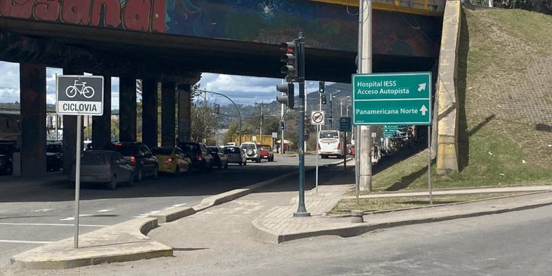
For the last mile of the route, the path turns away from the Machangara and follows a road through the Parque Industrial area. You could be forgiven for turning around and avoiding this last unattractive stretch. But for the completists who want to claim that they have ridden every km of this 13.5 km route, here’s what to expect.
The Ciclovía runs on a section of the Panamerica Norte highway, past the factories of Parque Industrial. This environment is visually the opposite of the natural beauty seen elsewhere on the ride and runs very steeply uphill. A strong rider can likely climb it, though I don’t fit that description and instead walked my bike uphill.
Another hazard of this section is that the path had a significant amount of dirt and small rocks on it – apparently rockslides from the hills above the street. The paved and protected route ends where Panamericana Norte meets Av. de las Americas. But if you cross that intersection, you’ll see a bike lane continuing right up to the platform of the Parque Industrial Tranvía stop. There, you and your bike can board the Tranvía for an easier trip home or to your starting point.
Call it a day or double back
You can hop on the Tranvía and head back into the Centro, or you could do what I did and turn around and ride it in the other direction. I walked my bike down the hill as the grade was so steep that I wasn’t sure that my brakes could take it. After I was down where the downward grade was more gentle, I got back on the bike and enjoyed coasting.
Pedaling got more difficult as I returned to Parque Los Eucaliptos as the upward grade became milder and more consistent. If you are in reasonably good condition and with a respectable number of miles in the saddle you could handle this stretch comfortably. I was not in such great condition so I took breaks and walked the bike in places.
And rather than ride a complete re-run of the same route, I took a shortcut back to the Centro, where I was to return my borrowed hybrid bike to its owner.
Paseo Tres de Noviembre offers historic buildings, river views, and places to eat and drink
This shortcut began at the Parque El Paraiso, at the corner of Av. Pumapungo and Paseo de los Cañaris. I followed Paseo Tres de noviembre west along the Tomebamba. This route goes below the Museo Pumapungo and is another beautiful and scenic ride, running alongside the Tomebamba, just below El Centro. On one side of the route are the restaurants, cafes, museums, and hotels on Calle Larga, overlooking the river.
Across the Tomebamba are historic buildings, the University of Cuenca, and the grand European-style Avenida Solano. Going down the Paseo 3 de Noviembre, we pass the steep stairways (escalinatas) that lead up to Calle Larga and El Centro. You see the landmark bridges, like the Broken Bridge, and the bridge with the names of women victims of violence are painted. The route here goes gently up and downhill and is sometimes on cobblestone. So take it slowly and carefully, to enjoy the full experience.

After crossing Avenida Loja, the route is segregated from regular traffic. It passes the vast Plaza Otorongo, home to such spots as the Flora Caffé, Café Otorongo, and occasional ferias libres. The route continues along the Tomebamba, passing the Jefferson Perez Coliseo across the river and ultimately running under Avenida Las Americas into “Gringolandia” and Puertas del Sol. There, you can stop at the neighborhood restaurants and cafes. If you have had enough pedaling at this point you can catch the Tranvía at the Ordoñez Lasso/Calle del Arrayán stop).
The Tres de Noviembre route can be a delightful finish to a ride along the complete Cuenca Unidad route or a trip on its own. Together, the two routes offer a chance to spend some time along the beautiful rivers that gave the city its name “Santa Ana de los Cuatro Ríos de Cuenca.”
TIPS
Use a bike with good gear shifts. There are fast, downhill sections where you’ll want to be in high gear and uphill sections where you’ll need low gear (unless you decide to walk the bike).
When crossing intersections, it is safest to get off the bike and carefully walk across the intersection, particularly when crossing the redondel. Cuenca drivers can be unpredictable.
Wearing a bike helmet is essential for safety. Padded bike gloves and bike shorts will make the ride more comfortable.
Sunday morning is a wonderful time to avoid traffic from motor vehicles, other bicyclists, and pedestrians.
Bring the map in the “Manual del Ciclista” which is accurate (except for the previously noted error about the northern terminus). And/or refer to Google Maps on your phone to track your precise location and identify places to visit.
The BiciCuenca office on Paseo Tres de Noviembre, just west of the Puente Juana de Oro, sells memberships in the BiciCuenca bike-sharing program. Bici Pública Cuenca - Bicicletas compartidas Cuenca (bicicuenca.com)
Wrapping Up
The “Ciclovía Cuenca Unida” takes riders by all four of Cuenca’s rivers and through the lineal parks. You now have information about the river views, the easiest starting point for downhill riders, detours with the best views, alternate loops, nifty sights, some great parks, places to stop for food and drink, and the TIPS above to get you started.
So, what are you waiting for? Jump on a bike and give it a spin.
For more information on bicycling in Cuenca, see my previous article.